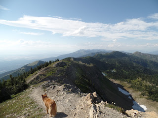
The plan this week was to do the Grinnell Glacier Hike on the East Side of Glacier in the Many Glaciers section of the Park. I did the math though and a 2.5 hour drive there, an 8 mile plus hike and 2.5 hour drive back did not compute. So instead we decided to do a hike in Jewel Basin which is just north of the Bob Marshall Wilderness area and only a 45 minutes drive. I decided on the 3.2 mile loop to a peak with 360 degree views. An added bonus is that Tucson can go too!
Jewel Basin is 15,349 acres of wilderness. Within the area there are 27 lakes and 35 miles of trails.
The trail climbs the highest point in the Jewel Basin Area, Mt Aeneas 7528ft
It's a beautiful drive heading towards the Swan Mountain Range
The paved road becomes dirt and climbs and curves steadily up the mountain for 7 miles.
Finally the parking lot for the trail head
I check out our route
and find out that the 717 3.2 mile "loop" doesn't include the 3.5 or better miles to get to the loop and back.
We ope to take trail 8 to 68 to the Picnic Lakes so Tucson can get a swim in earlier on.
and we're off!
As the trail ascends we start getting some good views.
After a mile or so, Tucson finds a watering hole
The mountain top looms ahead
We're almost to the notch and are rewarded with spectacular views. Of course I find that my camera batter on my good camera is dead so I am left with my phone and the little samsung camera we found in Tucson
A nifty little bridge
and Tucson wastes no time checking out the water

We rest here for about half an hour munching on trail mix, taking in the views and smelling the pine forest
Tucson decides to take a break as well
I figure the trail behind us must lead to the other lake
So we check it out
and it does! You can barely see at the top of the mount towards the right a block building which is a microwave a tower and just past the half way mark of the hike. Yes we have to hike to that other tall peak just above the snow patch
Might as well get started

More wildflowers along the way
Tucson stops for some shaved ice
The next ascent - oh boy!
I have a little help with my pull assist dog
Gary is following slow and steady
The end is near!
and the other side comes into view. We will be following that ridge to the Microwave Tower
Can't believe we made it. Gary had suggested we just turn around at the lakes as it was going on 5 pm then and we weren't even half way. He said let's take a vote - Tucson and I voted lets continue! Boy are we glad we did. The peak of Mt. Aeneas 7,528' it is the 2nd highest peak in Jewell Basin and the only one with a hiking trail to it. Whitefish MT is at 3,000'
Tucson is ready to move on

The 2nd half of the hike begins
I see the Microwave Tower ahead
A microwave tower and me with no popcorn!
There are the Picnic Lakes - we could have taken a shortcut up here
I thought the trail continued on the Ridge but it became a series of switchbacks on the other side of the mountain. I was worried that we were going onto a different trail and wouldn't find out until we got to the bottom and then would have to hike all the way back up. I had taken a picture of the map on my phone but it had up and died.
Fortunately almost a mile down the bottom we see a sign for Camp Misery where the trail head started
It is another 1.5 miles to the parking lot. A lot of Fireweed comes into view. I had always thought it a strange name for a hot pink flower but it gets its name not from its color but because it is one of the first things to grow after a fire.
Whitebark Pine forests, are experiencing tough times due to the combined effects of White Pine Blister Rust, Mountain Pine Beetle attacks, and lack of fire on the landscape. The Swan Range has been particularly hard hit with some areas experiencing over 90% whitebark pine mortality. This section was intentionally set on fire to try to regenerate a Whitebark Pine forest. Seedlings need fire areas to grow and it takes 60 years for the pine to generate cones.
The cone's seeds are scatted by birds and chimpmunks
At this point the 1.5 miles seems endless and again I am wondering in we got off the trail. The sun is going down and it is getting considerable cooler.
Finally the parking lot comes into view! I have never been so happy to see the truck! We started at 1:45 and finished at 7:45 and hiked a total of 9.5 miles.


No comments:
Post a Comment
Talk to us! Let us know what you think!